Lab 6: Using a Bluetooth GPS with an iOS Device
Lab
6: Using a Bluetooth GPS with an iOS Device
Introduction
This lab used the BadElf
GPS app with a Bluetooth GPS device to track the group’s movement as we
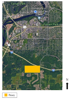
conducted a basic find and seek on the UW- Eau Claire campus (Figure 1).
Bluetooth connect devices, such as BadElf, are becoming increasingly popular.
As smartphones became increasingly accurate with internal GPS, it became more
cost efficient and convenient to have a GPS device attached to one’s smartphone
instead of large pieces of equipment. Today, smartphones and tablets are used
in a wide variety of geoscientist fields because it is more efficient and more
cost effective.
 |
| Figure 1. This is map of the location of the UW- Eau Claire campus within Eau Claire County, Wisconsin. |
There is a variety of app
that can be used on a smartphone that are compatible with BadElf. One of these
apps is Collector for ArcGIS. This app allows one to collect and update data
using the map or GPS and download maps to work offline. Another GIS and mapping
app is GIS4Mobile. This app is similar to the Collector for ArcGIS. This app
can perform inspections, documentations, data-collections, and registration. It
is also possible to synchronize GIS data with the collected field data. There
is also more recreational apps that are compatible with BadElf as well. One of
the apps used for travel is GrangerFX Scenic Maps. This app contains 3D maps of
specific areas around the world. The maps can be downloaded and used without
internet connection. Memory-Map Topo Maps is another app that can be used for
field navigation without internet connection. This app is useful for hiking and
other outdoor adventures. Users can plan out hikes and mark favorite hiking
spots using this app. Apps about astronomy are available as well. Redshift is
an app that always you to locate stars and planets in the night sky, as well
as, learn various facts about astronomy. There are a variety of other uses of Bluetooth
GPS and more are continued to be developed as smartphone technology continues
to improve (Figure 2).
 |
| Figure 2. These are all of the apps that are BadElf compatible and deal with GIS and mapping. Some of these were mentioned and described above. |
Methodology
Track
logs can be very helpful aid in field sciences. When working on a project after
the field exercise, a track log can be used to determine where a specific site
of interest was located or to jog ones memory. The first thing done in this lab
to start a track log was to search BadElf GPS in the app store. BadElf GPS is
only compatible on iOS devices or iPhones. Once the app is located and
downloaded from the app store, the Bluetooth then needs to be turned on. When
searching for a device make sure the GPS that is being used is the same device
the app is connected to. When many Bluetooth device are available, many will
show up but will not be the correct device. Once the Bluetooth is connects the
device will start to collect a track log. The smartphone screen doesn’t need to
be on while the track log collects data, making it very simple to collect field
data and a track log at the same time.
In
this lab, the track log was started and groups went throughout campus playing “hide
and seek” with a radio tracking and receiving device (Figure 3). After this
activity was done, the GPS devices were turned off. The students that had the
downloaded BadElf app then downloaded the track log to their smartphones. From
here, the track log was able to be shared via email or D2L. This data could
then be downloaded into ArcEarth and the track log projected onto its proper
GPS location (Figure 4). This data was then able to be transferring into layers
or features classes in ArcMap. A cartographically map was then able to be made
using ArcMap (Figure 5).
 |
| Figure 3. Image of group member using the tracking device during the "hide and seek" portion of the lab. |
 |
| Figure 4. The tracking log viewed in ArcEarth. |
| Figure 5. A map of the tracking log taken by BadElf GPS app and mapped within ArcMap. |
Conclusion
The BadElf
GPS app uses smartphone devices to collect track logs. This can be very helpful
in any outdoor activity. May it be for professional or recreational purposes.
The use of the BadElf GPS for professional field surveys always one to track
their movements throughout the field study in order to recall information back
at the lab or to assess what area may have been scarcely covered. The app can
also be used in hiking to map hiking trails for future use or for sharing with
others. Whether it is professional or recreational, the BadElf app has many
real life applications.
The
use of the BadElf GPS app in this lab was very introductory. It was a simple
track log throughout the UW- Eau Claire campus. The uses of the app were seen
though through this exercise. This app is helpful within the assessment of
field surveys or within hiking. It can also be used with other devices to make
it even more applicable to any outdoor situation. The BadElf app is a helpful
tool for geoscientists today.
References
BadElf. Compatible Apps. March 13, 2018, https://bad-elf.com/pages/compatible-apps#outdoor


Comments
Post a Comment